
 | Grundst眉ck |
 | Site |
 | Site |
| Item | SPF | XML | Change | Description | IFC2x3 to IFC4 |
|---|---|---|---|---|
| IfcSite | ||||
| OwnerHistory | MODIFIED | Instantiation changed to OPTIONAL. | ||
| CompositionType | MODIFIED | Instantiation changed to OPTIONAL. |
A site is a defined area of land, possibly covered with water, on which the project construction is to be completed. A site may be used to erect, retrofit or turn down building(s), or for other construction related developments.
NOTE Term according to ISO6707-1 vocabulary "area of land or water where construction work or other development is undertaken".
A site may include a definition of the single geographic reference point for this site (global position using WGS84 with Longitude, Latitude and Elevation). The precision is provided up to millionth of a second and it provides an absolute placement in relation to the real world as used in exchange with geospational information systems. If asserted, the Longitude, Latitude and Elevation establish the point in WGS84 where the point 0.,0.,0. of the LocalPlacement of IfcSite is situated.
The geometrical placement of the site, defined by the IfcLocalPlacement, shall be always relative to the spatial structure element, in which this site is included, or absolute, i.e. to the world coordinate system, as established by the geometric representation context of the project. The world coordinate system, established at the IfcProject.RepresentationContexts, may include a definition of the true north within the XY plane of the world coordinate system, if provided, it can be obtained at IfcGeometricRepresentationContext.TrueNorth.
A project may span over several connected or disconnected sites. Therefore site complex provides for a collection of sites included in a project. A site can also be decomposed in parts, where each part defines a site section. This is defined by the composition type attribute of the supertype IfcSpatialStructureElements which is interpreted as follow:
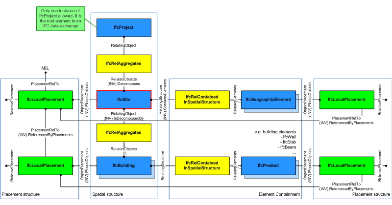
The IfcSite is used to build the spatial structure of a building (that serves as the primary project breakdown and is required to be hierarchical).
Figure 179 shows the IfcSite as part of the spatial structure. In addition to the logical spatial structure, also the placement hierarchy is shown. In this example the spatial structure hierarchy and the placement hierarchy are identical.
NOTE Detailed requirements on mandatory element containment and placement structure relationships are given in view definitions and implementer agreements.
|
Figure 179 — Site composition |
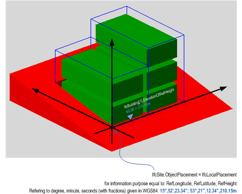
Figure 180 describes the heights and elevations of the IfcSite. It is used to provide the geographic longitude, latitude, and height above sea level for the origin of the site. The origin of the site is the local placement.
The provision of longitude, latitude, height at the IfcSite for georeferencing is provided for upward compatibility reasons. It requires a single instance of IfcSite and WGS84 as coordinate reference system.
For exact georeferencing (or referencing to any other geographic coordinate system other than WSG84) the entities IfcCoordinateReferenceSystem and IfcMapConversion have to be used to define an exact mapping of the project engineering coordinate system to the geographic (or map) coordinate system.
 |
|
Figure 180 — Site elevations |
HISTORY New entity in IFC1.0.
| # | Attribute | Type | Cardinality | Description | G |
|---|---|---|---|---|---|
| 10 | RefLatitude | IfcCompoundPlaneAngleMeasure | ? |
World Latitude at reference point (most likely defined in legal description). Defined as integer values for degrees, minutes, seconds, and, optionally, millionths of seconds with respect to the world geodetic system WGS84.
NOTE Latitudes are measured relative to the geodetic equator, north of the equator by positive values - from 0 till +90, south of the equator by negative values - from 0 till -90. | X |
| 11 | RefLongitude | IfcCompoundPlaneAngleMeasure | ? |
World Longitude at reference point (most likely defined in legal description). Defined as integer values for degrees, minutes, seconds, and, optionally, millionths of seconds with respect to the world geodetic system WGS84.
NOTE Longitudes are measured relative to the geodetic zero meridian, nominally the same as the Greenwich prime meridian: longitudes west of the zero meridian have negative values - from 0 till -180, longitudes east of the zero meridian have positive values - from 0 till -180. EXAMPLE Chicago Harbor Light has according to WGS84 a longitude -87.35.40 (or 87.35.40W) and a latitude 41.53.30 (or 41.53.30N). | X |
| 12 | RefElevation | IfcLengthMeasure | ? | Datum elevation relative to sea level. | X |
| 13 | LandTitleNumber | IfcLabel | ? | The land title number (designation of the site within a regional system). | X |
| 14 | SiteAddress | IfcPostalAddress | ? | Address given to the site for postal purposes. | X |
| # | Attribute | Type | Cardinality | Description | G |
|---|---|---|---|---|---|
| IfcRoot | |||||
| 1 | GlobalId | IfcGloballyUniqueId | Assignment of a globally unique identifier within the entire software world. | X | |
| 2 | OwnerHistory | IfcOwnerHistory | ? |
Assignment of the information about the current ownership of that object, including owning actor, application, local identification and information captured about the recent changes of the object,
NOTE only the last modification in stored - either as addition, deletion or modification. IFC4 CHANGE The attribute has been changed to be OPTIONAL. | X |
| 3 | Name | IfcLabel | ? | Optional name for use by the participating software systems or users. For some subtypes of IfcRoot the insertion of the Name attribute may be required. This would be enforced by a where rule. | X |
| 4 | Description | IfcText | ? | Optional description, provided for exchanging informative comments. | X |
| IfcObjectDefinition | |||||
| HasAssignments | IfcRelAssigns @RelatedObjects | S[0:?] | Reference to the relationship objects, that assign (by an association relationship) other subtypes of IfcObject to this object instance. Examples are the association to products, processes, controls, resources or groups. | X | |
| Nests | IfcRelNests @RelatedObjects | S[0:1] | References to the decomposition relationship being a nesting. It determines that this object definition is a part within an ordered whole/part decomposition relationship. An object occurrence or type can only be part of a single decomposition (to allow hierarchical strutures only).
IFC4 CHANGE The inverse attribute datatype has been added and separated from Decomposes defined at IfcObjectDefinition. | X | |
| IsNestedBy | IfcRelNests @RelatingObject | S[0:?] | References to the decomposition relationship being a nesting. It determines that this object definition is the whole within an ordered whole/part decomposition relationship. An object or object type can be nested by several other objects (occurrences or types).
IFC4 CHANGE The inverse attribute datatype has been added and separated from IsDecomposedBy defined at IfcObjectDefinition. | X | |
| HasContext | IfcRelDeclares @RelatedDefinitions | S[0:1] | References to the context providing context information such as project unit or representation context. It should only be asserted for the uppermost non-spatial object.
IFC4 CHANGE The inverse attribute datatype has been added. | X | |
| IsDecomposedBy | IfcRelAggregates @RelatingObject | S[0:?] | References to the decomposition relationship being an aggregation. It determines that this object definition is whole within an unordered whole/part decomposition relationship. An object definitions can be aggregated by several other objects (occurrences or parts).
IFC4 CHANGE The inverse attribute datatype has been changed from the supertype IfcRelDecomposes to subtype IfcRelAggregates. | X | |
| Decomposes | IfcRelAggregates @RelatedObjects | S[0:1] | References to the decomposition relationship being an aggregation. It determines that this object definition is a part within an unordered whole/part decomposition relationship. An object definitions can only be part of a single decomposition (to allow hierarchical strutures only).
IFC4 CHANGE The inverse attribute datatype has been changed from the supertype IfcRelDecomposes to subtype IfcRelAggregates. | X | |
| HasAssociations | IfcRelAssociates @RelatedObjects | S[0:?] | Reference to the relationship objects, that associates external references or other resource definitions to the object.. Examples are the association to library, documentation or classification. | X | |
| IfcObject | |||||
| 5 | ObjectType | IfcLabel | ? |
The type denotes a particular type that indicates the object further. The use has to be established at the level of instantiable subtypes. In particular it holds the user defined type, if the enumeration of the attribute PredefinedType is set to USERDEFINED.
| X |
| IsDeclaredBy | IfcRelDefinesByObject @RelatedObjects | S[0:1] | Link to the relationship object pointing to the declaring object that provides the object definitions for this object occurrence. The declaring object has to be part of an object type decomposition. The associated IfcObject, or its subtypes, contains the specific information (as part of a type, or style, definition), that is common to all reflected instances of the declaring IfcObject, or its subtypes.
IFC4 CHANGE New inverse relationship, change made with upward compatibility for file based exchange. | X | |
| Declares | IfcRelDefinesByObject @RelatingObject | S[0:?] | Link to the relationship object pointing to the reflected object(s) that receives the object definitions. The reflected object has to be part of an object occurrence decomposition. The associated IfcObject, or its subtypes, provides the specific information (as part of a type, or style, definition), that is common to all reflected instances of the declaring IfcObject, or its subtypes.
IFC4 CHANGE New inverse relationship, change made with upward compatibility for file based exchange. | X | |
| IsTypedBy | IfcRelDefinesByType @RelatedObjects | S[0:1] | Set of relationships to the object type that provides the type definitions for this object occurrence. The then associated IfcTypeObject, or its subtypes, contains the specific information (or type, or style), that is common to all instances of IfcObject, or its subtypes, referring to the same type.
IFC4 CHANGE New inverse relationship, the link to IfcRelDefinesByType had previously be included in the inverse relationship IfcRelDefines. Change made with upward compatibility for file based exchange. | X | |
| IsDefinedBy | IfcRelDefinesByProperties @RelatedObjects | S[0:?] | Set of relationships to property set definitions attached to this object. Those statically or dynamically defined properties contain alphanumeric information content that further defines the object.
IFC4 CHANGE The data type has been changed from IfcRelDefines to IfcRelDefinesByProperties with upward compatibility for file based exchange. | X | |
| IfcProduct | |||||
| 6 | ObjectPlacement | IfcObjectPlacement | ? | Placement of the product in space, the placement can either be absolute (relative to the world coordinate system), relative (relative to the object placement of another product), or constraint (e.g. relative to grid axes). It is determined by the various subtypes of IfcObjectPlacement, which includes the axis placement information to determine the transformation for the object coordinate system. | X |
| 7 | Representation | IfcProductRepresentation | ? | Reference to the representations of the product, being either a representation (IfcProductRepresentation) or as a special case a shape representations (IfcProductDefinitionShape). The product definition shape provides for multiple geometric representations of the shape property of the object within the same object coordinate system, defined by the object placement. | X |
| ReferencedBy | IfcRelAssignsToProduct @RelatingProduct | S[0:?] | Reference to the IfcRelAssignsToProduct relationship, by which other products, processes, controls, resources or actors (as subtypes of IfcObjectDefinition) can be related to this product. | X | |
| IfcSpatialElement | |||||
| 8 | LongName | IfcLabel | ? |
Long name for a spatial structure element, used for informal purposes. It should be used, if available, in conjunction with the inherited Name attribute.
NOTE In many scenarios the Name attribute refers to the short name or number of a spacial element, and the LongName refers to the full descriptive name. | X |
| ContainsElements | IfcRelContainedInSpatialStructure @RelatingStructure | S[0:?] | Set of spatial containment relationships, that holds those elements, which are contained within this element of the project spatial structure.
NOTE The spatial containment relationship, established by IfcRelContainedInSpatialStructure, is required to be an hierarchical relationship, where each element can only be assigned to 0 or 1 spatial structure element. | X | |
| ServicedBySystems | IfcRelServicesBuildings @RelatedBuildings | S[0:?] | Set of relationships to systems, that provides a certain service to the spatial element for which it is defined. The relationship is handled by the objectified relationship IfcRelServicesBuildings.
IFC4 CHANGE The inverse attribute has been promoted to the new supertype IfcSpatialElement with upward compatibility for file based exchange. | X | |
| ReferencesElements | IfcRelReferencedInSpatialStructure @RelatingStructure | S[0:?] | Set of spatial reference relationships, that holds those elements, which are referenced, but not contained, within this element of the project spatial structure.
NOTE The spatial reference relationship, established by IfcRelReferencedInSpatialStructure, is not required to be an hierarchical relationship, i.e. each element can be assigned to 0, 1 or many spatial structure elements. EXAMPLE A curtain wall maybe contained in the ground floor, but maybe referenced in all floors, it reaches. IFC2x3 CHANGE The inverse attribute has been added with upward compatibility for file based exchange. 脴\X | X | |
| IfcSpatialStructureElement | |||||
| 9 | CompositionType | IfcElementCompositionEnum | ? |
Denotes, whether the predefined spatial structure element represents itself, or an aggregate (complex) or a part (part). The interpretation is given separately for each subtype of spatial structure element. If no CompositionType is asserted, the dafault value 'ELEMENT' applies.
IFC4 CHANGE Attribute made optional. | X |
| IfcSite | |||||
| 10 | RefLatitude | IfcCompoundPlaneAngleMeasure | ? |
World Latitude at reference point (most likely defined in legal description). Defined as integer values for degrees, minutes, seconds, and, optionally, millionths of seconds with respect to the world geodetic system WGS84.
NOTE Latitudes are measured relative to the geodetic equator, north of the equator by positive values - from 0 till +90, south of the equator by negative values - from 0 till -90. | X |
| 11 | RefLongitude | IfcCompoundPlaneAngleMeasure | ? |
World Longitude at reference point (most likely defined in legal description). Defined as integer values for degrees, minutes, seconds, and, optionally, millionths of seconds with respect to the world geodetic system WGS84.
NOTE Longitudes are measured relative to the geodetic zero meridian, nominally the same as the Greenwich prime meridian: longitudes west of the zero meridian have negative values - from 0 till -180, longitudes east of the zero meridian have positive values - from 0 till -180. EXAMPLE Chicago Harbor Light has according to WGS84 a longitude -87.35.40 (or 87.35.40W) and a latitude 41.53.30 (or 41.53.30N). | X |
| 12 | RefElevation | IfcLengthMeasure | ? | Datum elevation relative to sea level. | X |
| 13 | LandTitleNumber | IfcLabel | ? | The land title number (designation of the site within a regional system). | X |
| 14 | SiteAddress | IfcPostalAddress | ? | Address given to the site for postal purposes. | X |
Spatial Composition
The Spatial Composition concept applies to this entity.
By using the inverse relationship IfcSite.Decomposes it references IfcProject || IfcSite through IfcRelAggregates.RelatingObject, If it refers to another instance of IfcSite, the referenced IfcSite needs to have a different and higher CompositionType, i.e. COMPLEX (if the other IfcSite has ELEMENT), or ELEMENT (if the other IfcSite has PARTIAL).
Spatial Decomposition
The Spatial Decomposition concept applies to this entity.
By using the inverse relationship IfcSite.IsDecomposedBy it references (em>IfcSite || IfcBuilding || IfcSpace by IfcRelAggregates.RelatedObjects. If it refers to another instance of IfcSite, the referenced IfcSite needs to have a different and lower CompositionType, i.e. ELEMENT (if the other IfcSite has COMPLEX), or PARTIAL (if the other IfcSite has ELEMENT).
Spatial Container
The Spatial Container concept applies to this entity.
If there are building elements and/or other elements directly related to the IfcSite (like a fence, or a shear wall), they are associated with the IfcSite by using the objectified relationship IfcRelContainedInSpatialStructure. The IfcIfcSite references them by its inverse relationship:
Property Sets for Objects
The Property Sets for Objects concept template applies to this entity as shown in Table 63.
Quantity Sets
The Quantity Sets concept template applies to this entity as shown in Table 64.
| ||||
Table 64 — IfcSite Quantity Sets |
Placement
The Product Local Placement concept applies to this entity.
The local placement for IfcSite is defined in its supertype IfcProduct. It is defined by the IfcLocalPlacement, which defines the local coordinate system that is referenced by all geometric representations.
FootPrint GeomSet Geometry
The FootPrint GeomSet Geometry concept template applies to this entity as shown in Table 65.
| ||||||||
Table 65 — IfcSite FootPrint GeomSet Geometry |
The foot print representation of IfcSite is given by either a single 2D curve (such as IfcPolyline or IfcCompositeCurve), or by a list of 2D curves (in case of inner boundaries).
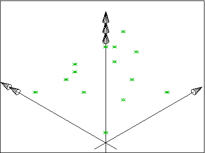
Survey Points Geometry
The Survey Points Geometry concept template applies to this entity as shown in Table 66.
| ||
Table 66 — IfcSite Survey Points Geometry |
The survey point representation of IfcSite is defined using a set of survey points and optionally breaklines. The breaklines are restricted to only connect points given in the set of survey points. Breaklines, if given, are used to constrain the triangulation.
The representation identifier and type of this geometric representation of IfcSite is:
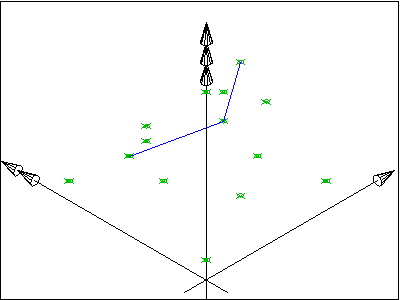
Figure 183 shows a set of survey points, given as 3D Cartesian points within the object coordinate system of the site. Figure 184 shows the result after facetation.
The set of IfcCartesianPoint is included in the set of IfcGeometricCurveSet.Elements.
 |
 |
Figure 183 — Site survey points |
Figure 184 — Site survey points facetation |
Figure 185 shows A set of survey points, given as 3D Cartesian points, and a set of break points, given as a set of lines, connecting some survey points, within the object coordinate system of the site. Figure 186 shows the result after facetation.
The set of IfcCartesianPoint and the set of IfcPolyline are included in the set of IfcGeometricCurveSet.Elements.
 |
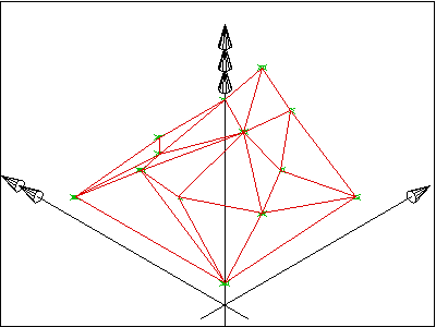 |
Figure 185 — Site breaklines |
Figure 186 — Site breaklines facetation |
NOTE The geometric representation of the site has been based on the ARM level description of the site_shape_representation given within the ISO 10303-225 "Building Elements using explicit shape representation".
Body Geometry
The Body Geometry concept template applies to this entity as shown in Table 67.
|
|
Table 67 — IfcSite Body Geometry |
The body representation of IfcSite is defined using a solid or surface model. Applicable solids are the IfcFacetedBrep or on the IfcFacetedBrepWithVoids, applicable surface models are the IfcFaceBasedSurfaceModel and the IfcShellBasedSurfaceModel.
The representation identifier and type of this representation of IfcSite is:
<?xml version="1.0"?>

<ConceptRoot xmlns:xsi="http://www.w3.org/2001/XMLSchema-instance" xmlns:xsd="http://www.w3.org/2001/XMLSchema" uuid="d16466b6-aae6-452e-9747-92eac94c88fe" name="IfcSite" status="sample" applicableRootEntity="IfcSite">

  <Applicability uuid="00000000-0000-0000-0000-000000000000" status="sample">

    <Template ref="0b92eef7-b33b-40e8-9042-6c2624a9f2dc" />

    <TemplateRules operator="and" />

  </Applicability>

  <Concepts>

    <Concept uuid="a7ebd0cc-b9f8-40f6-9f9e-53e24c4c1278" name="Spatial Composition" status="sample" override="false">

      <Template ref="8c0fd2f7-71bb-4e6e-8fdb-0c02b352f14a" />

    </Concept>

    <Concept uuid="7afd1725-9992-4b62-b6da-6f2c9bae8177" name="Spatial Decomposition" status="sample" override="false">

      <Template ref="667f8443-ecce-4a8d-a63f-931fab0453e0" />

    </Concept>

    <Concept uuid="8c4c40f5-f6ce-4a82-9ac3-1632962f9a75" name="Spatial Container" status="sample" override="false">

      <Template ref="61dd08ed-fd01-4955-9337-8afd284a0e6f" />

    </Concept>

    <Concept uuid="30a158e5-a30a-40d2-b81f-4349c37b91b5" name="Property Sets for Objects" status="sample" override="false">

      <Template ref="f74255a6-0c0e-4f31-84ad-24981db62461" />

      <TemplateRules operator="and">

        <TemplateRule Parameters="PsetName[Value]='Pset_LandRegistration'" />

        <TemplateRule Parameters="PsetName[Value]='Pset_SiteCommon'" />

      </TemplateRules>

    </Concept>

    <Concept uuid="2e2cc943-9dfa-461e-afdf-f6bcaf8a2d18" name="Quantity Sets" status="sample" override="false">

      <Template ref="6652398e-6579-4460-8cb4-26295acfacc7" />

      <TemplateRules operator="and">

        <TemplateRule Parameters="QsetName[Value]='Qto_SiteBaseQuantities'" />

      </TemplateRules>

    </Concept>

    <Concept uuid="33278c94-5472-4edf-86da-657909e20b18" name="Placement" status="sample" override="false">

      <Template ref="cbe85b5f-7912-4a43-8bb7-1e63bf40b26d" />

    </Concept>

    <Concept uuid="4edce3c7-a773-463d-8d0c-2e720b16fe38" name="FootPrint GeomSet Geometry" status="sample" override="false">

      <Template ref="9456d6d6-a62a-48b4-baff-be2e38baac9c" />

    </Concept>

    <Concept uuid="b737c722-c0d7-4f42-ba07-6b9a6aeb0a0a" name="Survey Points Geometry" status="sample" override="false">

      <Template ref="2a90f52f-7961-4dbd-8560-546e2d0b73bb" />

      <TemplateRules operator="and">

        <TemplateRule Parameters="" />

      </TemplateRules>

    </Concept>

    <Concept uuid="9d95191f-62a5-48b0-96d6-89bf319e55de" name="Body Geometry" status="sample" override="false">

      <Template ref="c446bd16-2de3-4b97-b34f-4446ac0badc2" />

      <TemplateRules operator="and">

        <TemplateRule Parameters="" />

        <TemplateRule Parameters="" />

      </TemplateRules>

    </Concept>

  </Concepts>

</ConceptRoot>
| # | Concept | Template | Model View |
|---|---|---|---|
| IfcRoot | |||
| Identity | Software Identity | General Usage | |
| Revision Control | Revision Control | General Usage | |
| IfcObjectDefinition | |||
| Classification Association | Classification Association | General Usage | |
| IfcObject | |||
| Object User Identity | Object User Identity | General Usage | |
| Object Predefined Type | Object Predefined Type | General Usage | |
| Object Typing | Object Typing | General Usage | |
| Property Sets with Override | Property Sets with Override | General Usage | |
| IfcProduct | |||
| Product Placement | Product Placement | General Usage | |
| Product Geometric Representation | Product Geometric Representation | General Usage | |
| IfcSite | |||
| Spatial Composition | Spatial Composition | General Usage | |
| Spatial Decomposition | Spatial Decomposition | General Usage | |
| Spatial Container | Spatial Container | General Usage | |
| Property Sets for Objects | Property Sets for Objects | General Usage | |
| Quantity Sets | Quantity Sets | General Usage | |
| Placement | Product Local Placement | General Usage | |
| FootPrint GeomSet Geometry | FootPrint GeomSet Geometry | General Usage | |
| Survey Points Geometry | Survey Points Geometry | General Usage | |
| Body Geometry | Body Geometry | General Usage | |
 <xs:element name="IfcSite" type="ifc:IfcSite" substitutionGroup="ifc:IfcSpatialStructureElement" nillable="true"/>

 <xs:complexType name="IfcSite">

  <xs:complexContent>

   <xs:extension base="ifc:IfcSpatialStructureElement">

    <xs:sequence>

     <xs:element name="SiteAddress" type="ifc:IfcPostalAddress" nillable="true" minOccurs="0"/>

    </xs:sequence>

    <xs:attribute name="RefLatitude" type="ifc:List-IfcCompoundPlaneAngleMeasure" use="optional"/>

    <xs:attribute name="RefLongitude" type="ifc:List-IfcCompoundPlaneAngleMeasure" use="optional"/>

    <xs:attribute name="RefElevation" type="ifc:IfcLengthMeasure" use="optional"/>

    <xs:attribute name="LandTitleNumber" type="ifc:IfcLabel" use="optional"/>

   </xs:extension>

  </xs:complexContent>

 </xs:complexType>
ENTITY IfcSite
SUBTYPE OF (IfcSpatialStructureElement);
RefLatitude : OPTIONAL IfcCompoundPlaneAngleMeasure;
RefLongitude : OPTIONAL IfcCompoundPlaneAngleMeasure;
RefElevation : OPTIONAL IfcLengthMeasure;
LandTitleNumber : OPTIONAL IfcLabel;
SiteAddress : OPTIONAL IfcPostalAddress;
END_ENTITY;
 Instance diagram
 Link to this page